Over the years, several attempts have been made to reveal the stratigraphy of the prolific hydrocarbon bearing Tano Basin in Ghana. However, with over two hundred well locations drilled in the shallow to deep water seismic coverage, there is a need to build on previous stratigraphic knowledge using recent, relevant data and available reports. Thus, this paper reviews the stratigraphy of the Tano Basin from available well data and reports. This review produced a summarized chronostratigraphic framework showing the various lithofacies distributions with the sedimentation periods through geologic time. The lithic fill in the Basin is controlled by notable structural configuration, a result of the rifting events which typically gave rise to two major depocenters suites amongst other. The stratigraphy of the Tano Basin is underlain by Precambrian Basement rocks, followed by sedimentation from the Pre-Aptian to Recent, associated with notable undifferentiated stratigraphic gaps, as either hiatuses or unconformities. The authors recommend further studies to ascertain the provenance and depositional processes that geologically characterize some of the interesting revelations such as the localized Cenomanian calcarenite sediments, undifferentiated Aptian to Albian volcanic/ igneous intrusion amongst others to collapse or validate the diverse proposed hypothesis.
Keywords:Tano basin, Unconformities, Calc arenite, Cenomanian, Stratigraphy
The West African Transform Margin (WATM) is a notable hydrocarbon-bearing geologic province along the coast of West Africa.1 The geographical location extends from the western coastal axis of Cote d’Ivoire, Ghana, Togo, Benin and to eastern Nigeria. It hosts a suite of sedimentary basins such as the Ivory Coast, Tano, Saltpond, Keta, Benin Basin and the Dahomey Embayment in the northwestern portion of the Gulf of Guinea. This family of basins share common geological characteristics such that they are wrench modified and infilled by rocks that are Paleozoic to Holocene.2 The Tano Basin Figure 1 is a member of the family group of Basins along the WATM. This coastal Tano Basin occupies largely offshore and minor onshore extension in southwestern Ghana, with an aerial extent of at least 3000 square kilometers.3
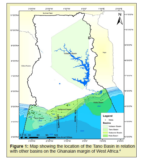
The Basin is also referred to as Western Basin or Cape Three Points Basin, and it has been accorded the Cretaceous geologic age.4,5 Similar and peculiar geological observations i.e., tectonics, structures and stratigraphy form the bases to relate and correlate the Tano Basin to some Brazilian Basins as conjugate pairs.6 However, the Suriname-Guyana Basins in the Northeast-South-American margins also bear similar characteristics to the Tano Basin.7
Dated back to 1896 and up until now, the Tano Basin has been noted for its potential hydrocarbon resources.8-11 The occurrences of oil seepages attracted earlier explorers to search for oil and gas onshore in the 1890s. Exploration continued to the offshore regions as efforts were made to understand the petroleum systems of the Basin. The year 2007 marked a breakthrough with the discovery of the commercial Jubilee field.12-14 The drilling campaign boomed exponentially following the jubilee discovery and this led to several other discoveries, with some developed into subsequent hydrocarbon-producing fields like the Tweneboa Enyenra and Ntomme (TEN) and Sankofa Gye-Nyame fields.
In all this, attempts have been made by some researchers to reveal the stratigraphic outlook of the Basin with its geologic ages using Basin analysis activities. Works of the Ghana National Petroleum Corporation (GNPC),3,4,6,10,15,16 and others have had a fair share of revealing the stratigraphy of the Basin with available wells and seismic information. As a matter of fact, more than 200 (Two) hundred well locations have been drilled in the Tano Basin.17 Following this, it is essential to update the stratigraphic knowledge of the Tano Basin. Thus, this paper aims to generate a chronostratigraphic summary of the Tano Basin from the available well and seismic data.
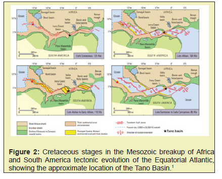
The Cretaceous Tano Basin is a marginal sag basin which overlies the remnants of a wrench-modified, interior fracture basin formed prior to the continental rifting and opening of the Atlantic Ocean in the Early Cretaceous. The formation of the Tano Basin just like other Basins on the WATM was a consequence of the Atlantic Rift System which was initiated in the Late Jurassic when the paleocontinents of South America and Africa began to break up and drifting occurred Figure 2. The Basin is believed to have evolved through a complexity of tectonic events over geologic time, and architecture as continental to oceanic rifting in a large-scale transform fault.18 The continental rifting events resulted in a pull-part basin in the Late Jurassic but modification followed by wrench tectonic events during the Mesozoic Era. The rift propagated in the eastward direction triggered an oblique motion, which translated to transform faulting, subsidence, fracture zones and subsequent sag that has reflected tectonic imprints in the Tano Basin.19,20 Some of the principal effects of this tectonic complexity led to the formation of localized sub-basin in some offshore locations.21
The Romanche Fracture Zone (RFZ) is one of the three main WSW-ENE trending structures in the Gulf of Guinea that intercepts the Tano Basin Figure 3. However, the RFZ has been stable flow lines that have contributed to the tectonic evolution and structures we have in the Basin.

The three main tectonic phases (pre-rift, syn-rift and post-rift) in the Tano Basin controlled the accommodation spaces which subsequently allowed for lithic basin fill.22 The accommodation space created by the opening and the deepening of the South Atlantic Ocean was filled with continental and marine sediments which range from Early Cretaceous to the Recent.23 Clastics supplied to the Basin were contributed from some river sources like the River Ankobra and Tano, and there has been direct evidence of sediment delivering shelf delta systems, as it is responsible for the large deposition of turbidites in the slope to the basin floor.4,9 However, the average thickness of the sedimentary fill within the Tano Basin is at least 3km.1 The present-day Tano Basin is characterised by a topographical steep nature and a broad continental shelf along its continental margins. The Cote D’Ivoire-Ghana Ridge (CIGR) and Ghana Escarpment (GE) intercepts parts of the Tano Basin.6
The Cretaceous Composite Total Petroleum System (CCTS) exists in the Tano Basin just like other basins on the WATM, where the principal sources rocks are the Albian, Cenomanian and Turonian marine shales, the reservoirs are the Upper Cretaceous sandstones, the trapping configuration articulated by fault blocks, syn-transform structural and stratigraphic traps, and sealing provided by intraformational marine shale and shale/mud filled channels.1 The Basin has identifiable plays such as the Albian, Cenomanian, Turonian, Campanian and Maastrichtian.5
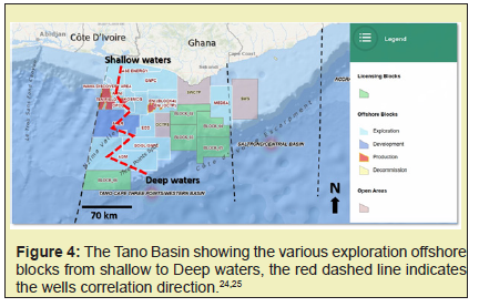
In line with the aim of the study, some relevant literatures were consulted. Some of the works of Davies,3 Attoh,6 Brownfield and Charpentier,1 Dailly,15 and Bempong4 amongst others, formed the core contributors to the discussions. Also, some relevant well information (Biostratigraphy and End of well reports), as well as earlier stratigraphic sections by the Ghana National Petroleum Corporation (GNPC) were used. With over 200 (Two hundred) wells drilled so far in the Tano Basin, representative wells in each exploration block according to the 2022 Ghana Offshore Activity Map created by the Petroleum Corporation of Ghana were also taken into consideration as a correlation guide Figure 4. In all, at least two (2) representative wells were selected to represent each of the licensing blocks, and they were correlated from the North to the South (shallow to deepwaters). Specifically, the well reports were reviewed for the lithofacies distribution along the correlated directions with respect to the associated geologic time interval, generally from the Paleozoic to the recent.
Review of previous works
GNPC26 built a stratigraphic sequence of the Tano Basin based on available well and seismic information. Some of the discoveries made in the near onshore to shallow waters environments, such as the North and South Tano discoveries constrained the results. The stratigraphic presentation spans the geologic interval from the Lower Cretaceous to the Quaternary Figure 5. Basically, the tectonic events that characterised the Basin formation were labelled and expressed as rift sequence and drift sequence. The rift sequence dominated the Lower Cretaceous (Aptian to Albian interval) while that of the drift sequence is from the Upper Cretaceous to the Quaternary. The rift sequences represent the onset of the rifting as the South Atlantic opened while the drift sequence is expressed by a post-rift thermal sag with flexures (sediment loading) triggered by oceanward subsidence.
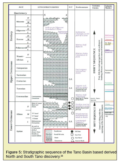
The variation of lithofacies reported was sandstone, sand/silt mix, shale and limestone. Unconformities/ gaps in the deposition were recorded as well. Shale dominated the lithofacies from the Turonian to the Lower Maastrichtian. The limestones dominated the Cenomanian with conspicuous unconformity which cuts into the Upper Albian and appeared as channels/canyons.
The Upper Maastrichtian to Tertiary interval bears mostly sand/silt lithofacies with identical unconformity/sedimentation gaps patterns at the Maastrichtian, Paleocene and Eocene levels. However, there are virtually no stratigraphic records of the Oligocene from the North to the South Tano discovery. This erosion or unconformity cuts into the Eocene level, being expressed as submarine channel features. This systematic erosion has been termed the Miocene-Oligocene Unconformity (MOU). Notable seismic markers were the Base Cenomanian, Turonian, Santonian Marker, Lower Eocene and others.
The RFZ propagate through the Equatorial Atlantic Region and the Gulf of Guinea Province. Thus, Attoh6 sought to investigate this eastern propagation of the RFZ which intercepts parts of the Tano Basin. They revealed from the investigation that the stratigraphic records of the Tano Basin formed from the effect of the transpression and uplift on the Romanche transform margin from the evaluation of available multichannel seismic reflection data from offshore Ghana. Again, the three major sedimentary sequences were captured as pre, syn and post-rift strata in the calibrated seismic profiles. The pre-rift sequence is largely the Paleozoic strata which ranged from Devonian to Carboniferous age rocks. The Aptian to Albian distinct siliciclastic continental facies characterises the syn-rift which was a resultant deposition of the continental-continental shearing stage. Subaerial erosions manifested on the seismic stratigraphic records with lateral variation and crustal thickening and folding, all due to the effect of ridge transform tectonic events.
Brownfield and Charpentier1 also captured aspects of the stratigraphic sequence of the Tano Basin while reporting on the Geology and Total Petroleum Systems of the Gulf of Guinea Province (GoGP) of West Africa. They indicated that the Tano Basin bears peculiar geological relation to other basins along the passive margins to the South Atlantic regions such that, there is the absence of halokinesis and the dominance of transform tectonics. Generally, they stated that the tectonic evolution of the GoGP is in three phases and each phase bears peculiar stratigraphic sequences. The first phase is the intracratonic Precambrian to Triassic rocks and continental to marginal marine Jurassic to Lower Cretaceous rocks while the second phase is the Lower Cretaceous to the Late Albian rocks, and the third phase is the Cenomanian to Holocene rocks. The lithofacies associations of these phases were well discussed in their reports.
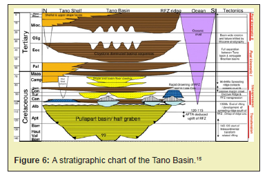
Dailly15 discussed the stratigraphy of the Tano Basin when looking at the Jubilee field discovery and its co-relation to the exploration of Cretaceous stratigraphic traps in the GoG. The major highlight described the depositional focus of the Basin as a thick deep-water clastic sequence belonging to the Upper Cretaceous, and a modest Tertiary section. A chronostratigraphic chart was one of their core contributions to understanding the Tano Basin Figure 6. The rock sequence discussed ranged from the Jurassic to the Tertiary. Generally, the lithofacies are the shelf and upper slope facies, the widespread claystone basal sequences, slopes and basin floor clastics, carbonate reefs and undifferentiated continental facies. The Jurassic were undifferentiated pre-rifted continental rock. Some of these rocks were noted at the Albian and Cenomanian levels. Also, the shallow to shelf areas had some older mud-filled canyons cutting through from Campanian to the Upper Cenomanian level, and a younger Tertiary canyon. Carbonate reefs dominated the Cenomanian level in the shelf region and the zones closer to the RFZ ridge from the Cenomanian to the Coniacian. Notably, the stratigraphy of the Tano basin is styled by the tectonic configurations; which are transtension, transpression, post kinematics I and post kinematics II.
Bempong16 applied sequence stratigraphic principles to understand the depositional settings and hydrocarbon prospectivity of the Campanian interval of the Basin using seismic and well data. The Campanian interval was dominated by a slope fan of about 410m thickness, with lithofacies successions of mud/shale with sand intercalation. Although the Campanian interval represented a low system tract, a period that allowed continental algae-rich freshwater run-off to the lowered erosional base. Thus, accounting for the clastic sedimentation (sands) encountered in the Campanian interval.
Akaba11 studied the regional stratigraphic framework of the Tano Basin, with extension to the other marginal basins of Ghana, using the principles of sequence stratigraphy. He suggested that the lithic basin-fill within the various stratigraphic intervals of the Tano Basin had stacking patterns that reveal the presence of both alternating fining-upwards and coarsening-upwards facie.
Stratigraphic relation of the Tano Basin to other coastal basins in Ghana
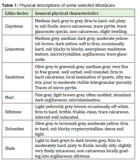
The Tano Basin bears peculiar stratigraphic relations to other coastal basins of Ghana i.e., the Central/Saltpond Basin and Accra/Keta Basin. Some workers are of the view that the Basin should be grouped as one i.e., offshore/marginal basins of Ghana. Furthermore, others have suggested that they should be grouped as one but recognized as individual sub-basins of the bigger marginal Basins of Ghana. However, in relation to the geologic age of formation, there seem to be some markable differences. The Tano and Keta Basin are Cretaceous in geologic age while the Saltpond Basin is Paleozoic. The three Basins all received a fair share of the wrench tectonic that occurred in the Cretaceous in the GoGP with similar geological characteristics and infill rocks from the Paleozoic to Holocene.2 It is important to note that there seems to be no parallel sedimentary fill across the Tano Basin and the other coastal basins of Ghana. However, the Tano Basin and the Keta Basin have identical stratigraphic sequences which agree with their tectonic stages i.e., the pre-rift, syn-rift and post-rift stratigraphic sequences. Some of the Devonian and Carboniferous aged sequences encountered in the deepest wells of the Central/Saltpond Basin can be correlated to similarly aged sequences of the Tano Basin.1,15 However, this relation can only be valid based on well-calibrated seismic correlation for the two Basin, because the number of wells drilled so far in the Tano Basin is yet to penetrate the Devonian/Carboniferous aged geologic interval. Notably, the clastics that fed into the Tano Basin in the Cenozoic Era were largely received from the paleo Volta River drainage systems at a time when the basin had undergone reorganizations.15 Some of the physical descriptions of the lithofacies are presented in Table 1. The description provided was obtained from mud logging of a selected well.
Chronostratigraphic discussions
Sedimentation in the Tano Basin is structurally controlled as earlier stated. Two major depocenters suites have been recognized. They are the northern and southern depocenters suites.15 These depocenters are like mini pockets and localized basins, which are separated from one another by a large transpressional ridge called the South Dixcove Ridge. The South Tano ridge is one of the notable examples of northern depocenter suites. In all, most of the ridges formed are a ripple effect of the RFZ. The Ghana National Petroleum Corporation (GNPC) has several groupings within the Tano Basin such as; Shallow Water Tano, Central Tano, Deep Water Tano, Cape-Three-Point, Deep Water Cape-Three-Point and more. These sub-groups by GNPC are based on factors such as local geological evolution, the expected petroleum play type, the geological interval of focus for the Late Lower to Upper Cretaceous reservoirs, source rocks and sealing potentials.
The chronostratigraphic summary of the Tano Basin shows that bathyal and neritic claystone are the dominant lithofacies and are widely spread from shallow to deep waters Figure 7. The Precambrian Basement rocks are the oldest when discussing the stratigraphy of the Tano Basin.
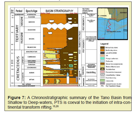
The nature, types and specific features of rocks that characterise the Precambrian are unknown because no well has been drilled yet to that depth. However, general geological reasonings will comfortably attribute the likely kinds of rocks to be that of conventional or typical basements rocks of most sedimentary basins worldwide. For the pre-Aptian to Albian Age interval which coincides with the pre-rift or pre-transform tectonic evolution stages, continental rocks have been speculated and most probably siliciclastic compositional rocks.1 This uncertainty was cleared by Kjemperud,2 when they reported conglomerate and sandstone beds of considerable thickness were deposited in the continental environment. To the adjacent western basin of the Tano Basin i.e., the Côte d'Ivoire basins, Lower Carboniferous rocks have been encountered in one of the wells (CTS-1 namely) drilled.27 Moreso, these equivalent Paleozoic rocks crop out at the Cape Three Points. The eastern adjacent Keta Basin which bears a similar pre-transformed stage was recorded as a period of non-deposition and packed with numerous erosional activities. Due to the nature of the direction of erosion which trended in the eastward direction, it is presumed that most of these Jurassic rocks were preserved in the Tano Basin.1
The syn-transform/ syn-rift stage spans the Aptian to Albian Age. The Aptian level is capped by lacustrine shale deposition and some localized undifferentiated Jurassic/volcanic intrusions. The occurrences of these intrusive and volcanic rocks aptly indicate geologic activities such as volcanism and faulting were initiated in the Early Jurassic.1 Shallow marine sands are pockets in a neritic claystone blanket though with eroded/missing rock records at the far deep waters areas. The Albian showed more shallow marine sands pinching out at the bathyal claystone. There were localized turbiditic fan deposits dispersed in the deeper water terrains. This syn-transform deposition was mostly in a continental and marine environment in the latter phase.2,27 The regional Albian Unconformity (AU) is a clear indication of the cessation of the syn-rift stage as it separates most of the Albian from the Cenomanian.28,29 The conjugate marginal basins of Brazil bear the AU and these occurrences formed the basis to support the fact that the two continents (South America and Africa) were together in some geologic past as they all share similar geologic histories.1 The post-transform lithofacies were deposited in an alternating transgression and regressive cycle, although there was a major Cenomanian flooding event which facilitated most of the pelagic carbonate deposition.15 Some geologic processes and effects conditioned the deposition of the calc-arenite facies. However, an unproven/untested hypothesis suggests that most of the calcarenite encountered was a result of eroded sandstones rich in quartz minerals from the RFZ ridges in the adjacent slope to basin floor terrains, which were then incorporated into the carbonates deposits. A close observation of the seismic profile from the shallow to the deepwater shows that some of the Turonian and Cenomanian sediments are missing or eroded, particularly close to the vicinity of the shallow water environment. The shallow marine sands encountered at the Maastrichtian and Campanian levels are pockets in neritic claystone while the farther turbidites fans and sands are localised in the bathyal claystone. The occurrences of glauconite in association with the sands at the Campanian level suggest a shallow marine environment. Though localized carbonate occurrences were encountered at the Maastrichtian and Santonian levels. Some other localized unconformities are seen in the Lower and Upper Campanian levels. However, the larger missing sections are at the Turonian and Cenomanian levels near the nearshore environments.
The Cretaceous and the Tertiary intervals are differentiated by a regional marker on most seismic profiles in the Tano Basin. As a matter of fact, this regional seismic marker is referred to as the Base Tertiary or KT Boundary. This regional seismic marker is a bright event with positive amplitude reflection traces in most seismic sections.16 The Tertiary Period represents parts of the post-transform sequences as largely bathyal and Neritic claystone with numerous occurrences of unconformities, erosional systems and minor localized shallow marine sands. This major unconformity/erosional system is the regional Miocene-Oligocene Unconformities (MOU). The MOU is an erosional system that characterizes the Mid-Tertiary stratigraphic intervals of the Tano Basin.1,16 Kjemperud attributed the cause of this MOU to a thermal subsidence event during the Tertiary period. Although, Attoh2 suggested that the MOU was due to a transpressional deformation associated with crustal thickening and folding, triggering subaerial erosions that are observed on seismic and well data. However, Dailly15 suggested that there was major slumping, and possible basin rotation in the Tertiary Period that could have led to the formation of the MOU. Sedimentation in the Tano Basin continues with contributions from pelagic and hemipelagic, typically of clastics depositional processes.
A stratigraphic discuss of the Tano Basin has been presented based on the available literature, coupled with information derived from seismic and well data from selected wells. There are notable similarities and differences between the Tano Basin with the other coastal Basins of Ghana. Sedimentation in the Tano Basin is styled according to structural configurations and the depobelts which align with the tectonic evolution of the Basin. The lithofacies discussed were in context with the sequences of the rift stages i.e., the pre-rift, syn-rift and post-rift. The summarized chronostratigraphic framework produced reflects the lithofacies distribution along a chosen correlation line from the shallow to deep waters. The neritic and the bathyal claystone are the most abundant of all the lithofacies. Shallow marine sands were dominants at the Maastrichtian, Campanian, Santonian to Coniacian, Albian and Aptian levels. The turbidities fans/sandstones were more present farther at the deep-water regime. Several localized unconformities/hiatuses sandwich the depositional processes in the Basin. However, there are undifferentiated volcanic/igneous intrusions at the Aptian to Albian levels even though the Jurassic Period was characterized by a lot of volcanic activities and faulting. There are two major regional unconformities i.e., the older Albian unconformities and the younger Miocene-Oligocene unconformities, and they all depict peculiar geological events in the Tano Basin. In all, there is a call to look into some of the interesting revelations such as the geological process and events that gave rise to the Cenomanian calc-arenite sediments and many others.
The authors are grateful to the African Centre of Excellence, Centre for Oilfield Chemicals Research, University of Port Harcourt, Nigeria and University of Mines and Technology, Tarkwa, Ghana for the research supports. Also, we thank the Ghana National Petroleum Corporation (GNPC) for making available their library and other facilities for this study.
None.
Author Declares that there is conflicts of interest.
- 1. Brownfield ME, Charpentier RR. Geology and total petroleum systems of the Gulf of Guinea Province of West Africa. U S Geological Survey Bulletin. 2006;2207-C:1-39.
- 2. Kjemperud A, Agbesinyale W, Agdestein T, et al. Tectono-stratigraphic history of the Keta Basin, Ghana with emphasis on late erosional episodes. Bulletin des Centres de recherches exploration-production Elf-Aquitaine. Mémoire. 1992;13:55–69.
- 3. Davies DW. The Geology and Tectonic Framework of the Republic of Ghana and the Petroleum Geology of the Tano Basin. Southwestern Ghana. An unpublished consultancy report prepared for Petro-Canada International Corporation on behalf of GNPC. 1986;24.
- 4. Bempong FK, Mensah CA, Bate BB, et al. Seismic Chronostratigraphic Illustration of the Tertiary Section in Tano Basin, Southwestern Ghana. Petroleum and Coal. 2021b;63(3):742-750.
- 5. Tetteh JT. The Cretaceous Play of Tano Basin, Ghana. International Journal of Applied Science and Technology. 2016;6(1):1-10.a.
- 6. Attoh K, Brown L, Guo J, et al. Seismic stratigraphic record of transpression and uplift on the Romanche transform margin, offshore Ghana. Tectonophysics. 2004;378(1-2):1-16.
- 7. Kelly J, Doust H. Exploration for the Late Cretaceous Turbidites in the Equatorial African and Northeast South American margins. Netherlands Journals of Geosciences. 2016;95(4):393-403.
- 8. Boateng MO. Oil exploration and production in Ghana. In National Forum on Oil and Gas development, GIMPA, Accra – Ghana, February; 2008.
- 9. Adda G. The Petroleum Geology of Ghana. Petroleum Commission Newsletter, Ghana Upstream News. 2013;1:2-6.
- 10. Bempong FK, Ozumba BM, Hotor V, et al. A Review of the Geology and the Petroleum potential of the Cretaceous Tano Basin of Ghana. Journal of Petroleum and Environmental Biotechnololgy. 2019;10(4):1-8.
- 11. Akaba PA. Integrated regional geological and sequence stratigraphy framework of the offshore Ghana Margin, Gulf of Guinea Province, West Africa: Implications for basin-fill, evolution and prospectivity. 2021. A PhD thesis submitted to the Department of Geological Engineering, Faculty of Civil and Geo-Engineering Kwame Nkrumah University of Science and Technology, Kumasi, Ghana.
- 12. Staken M. Ghana’s Oil Industry: Steady Growth in a Challenging Environment. Oxford Institute of Energy studies paper. 2018.
- 13. Abudu H, Sai R. Examining prospects and challenges of Ghana’s petroleum industry: A systematic review. Energy Reports. 2020;6:841-858.
- 14. Akaba PA, Owusu JA, Apesegah E, et al. Spatiotemporal evolution of potential source rocks in the cretaceous stratigraphic units, offshore Ghana. Petroleum and Coal. 2022;64(1):20-33.
- 15. Dailly P, Henderson T, Hudgens E, et al. Exploration for Cretaceous stratigraphic traps in the Gulf of Guinea, West Africa and the discovery of the Jubilee Field: a play opening discovery in the Tano Basin, Offshore Ghana. Geological Society of London Special Publications. 2013;369(1):235-248.
- 16. Bempong FK, Ehinola OA, Apesegah E, et al. Sequence Stratigraphic Framework, Depositional Settings and Hydrocarbon Prospectivity of the Campanian Section, Tano Basin, Southwestern Ghana. Petroleum and Coal. 2021a;63(1):204-215.
- 17. Addison V. Eyeing exploration opportunity in Ghana. Hart Energy Publication. 2020;95(11).
- 18. Rüpke LH, Schmid DW, Hartz HE, et al. Basin Modelling of a Transform Margin Setting: Structural, Thermal and Hydrocarbon Evolution of the Tano Basin, Ghana. Petroleum Geoscience. 2010;16(3):283-298.
- 19. Blarez E, Mascle J. Shallow structures and evolution of the Ivory Coast and Ghana transform margin. Marine Petroleum Geology. 1988;5(1):54-64.
- 20. Nora Herbst IA, Dailly P, Dribus JR, et al. Basin to Basin: Plate Tectonic in Exploration, Oilfield Review Autumn. 2012;24(3):38-57.
- 21. Anon. Final Geologic well report: Cheetah-1X. Vanco Ghana Ltd. 2012;11.
- 22. Garry P, Atta Petters D, Achaegakwo C. et al. Source - Rock Potential of the Lower Cretaceous Sediments in SD – 1X well, Offshore Tano Basin, South Western Ghana. Petroleum and Coal. 2016;58(4):1-14.
- 23. Kesse GO. The Mineral and Rock Resources of Ghana, AA Balkema Publishers, Rotterdam, Netherlands, 610. 1985.
- 24. Anon. Ghana offshore Activity Map by Petroleum Commission of Ghana. 2022.
- 25. Petroleum Commission Ghana. Ghana offshore Activity Maps. 2023.
- 26. Ghana National Petroleum Corporation. Ghana Hydrocarbon Potential. Tano and Cape Three Points. Unpublished report. 2004;1:12.
- 27. Tucker JW. Aspects of the Tano Basin stratigraphy revealed by recent drill in Ghana. In Curnelle R, editors, Géologie Africaine–1er colloques de stratigraphie et de paléogéographie des bassins sédimentaires ouest-Africains, 2e Colloque Africain de Micropaleontologie, Libreville, Gabon: Elf Aquitaine, Mémoire.1992;13:153-159.
- 28. Chierici MA. Stratigraphy, palaeoenvironments and geological evolution of the Ivory Coast-Ghana basin. Bulletin des Centres de recherches exploration-production Elf-Aquitaine. Mémoire. 1996;16:293-303.
- 29. MacGregor DS, Robinson J Spear G, et al. Play fairways of the Gulf of Guinea transform margin. In Arthur TJ, MacGregor DS, and Cameron, NR, editors., Petroleum geology of Africa—New themes and developing technologies: Geological Society, London, Special Publication. 2003;289.

